
Can We Stop with the TV Weather Hype?
Could the nation’s TV meteorologists tone down the weather hype a bit?
Lately, instead of being told it might drizzle soon in our area, TV weather forecasters have taken – Steve Karnaki style – to zooming out on their weather maps dramatically and cranking up their meteorological alarmism. Might this be a bid to boost ratings? I give it a 47.23 percent chance over the next two-to-four hours.
The entire nation, we are informed, will soon be pelted with gorilla hail from super typhoons, bomb cyclones, thundersnow, and firenados, sweeping in along Jet Stream atmospheric rivers from the Pacific La Niña, and resulting in derechos, macrobursts, avalanches, mudslides, wildfires, power grid failures, delayed school openings, and even the rapid intensification of haboobs.
All this is also confirmed by the European Model, apparently, though we are never shown her photo.
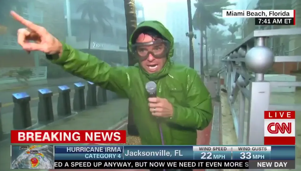
Just this past Sunday, one TV weather forecaster – News 8 Chief Meteorologist Eric Snitil from Rochester, New York – posted this morsel of hysteria to Facebook at precisely 12:38 p.m.:
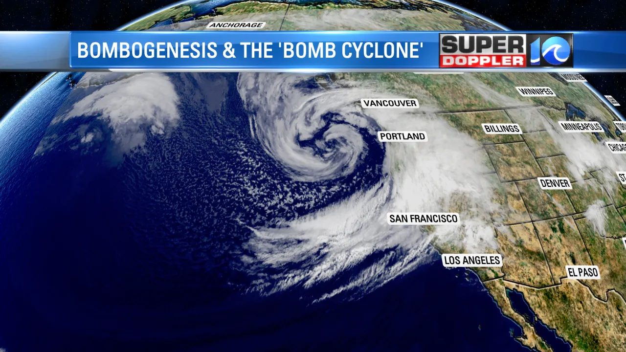
“BOMB CYCLONE: You might hear the term tossed around with tomorrow's powerful Great Lakes low. While it sounds cartoonish, it's an actual meteorological term used to describe rapid cyclogenesis (when a storm strengthens really fast). The latest HRRR drops the low pressure down to 974 mb near Georgian Bay Monday morning. That is a very strong storm in this part of the world. It will churn up monster waves on the Great Lakes and could cause power outages alongside downed trees. After that, bitterly cold air rushes in to attempt to fill the low, kicking off a round of lake effect snow. 2025 comes to a close with a bang.”

How Snitil managed to use the term “cyclogenesis” rather than the more alarmist meteorological term “bombogenesis” is beyond me. But, I like the “monster waves” bit.
And, in case you’re wondering, “bombogenesis” is actually a precisely defined and calibrated meteorological term. “The intensification required to classify as 'bombogenesis' varies by latitude,” the National Oceanographic and Atmospheric Administration (NOAA) tells us. “At 60 degrees latitude, it is a drop of at least 24 millibars (24 hectopascals) over 24 hours. At the latitude of New York City, the required pressure drop is about 17.8 millibars (17.8 hectopascals) over 24 hours.”
And what, you may well ask, is an “hectopascal”? Well, it’s defined as “100 pascals” by SensorOne, a pressure measuring company leading us around in circles. They do, however, elaborate: “A hectopascal (hPa) is a unit of pressure, primarily used in meteorology, meaning 100 pascals, and it's numerically identical to the older unit, the millibar (mb), making it ideal for measuring atmospheric pressure (e.g., 1013 hPa or 1013 mb at sea level).”
Of course, this leaves aside why the older unit, the lowly millibar, just wasn’t good enough. Especially because it’s precisely the same and requires fewer letters!
A millibar is, of course, 1/1000 of a “bar” which is defined tautologically by Merriam-Webster as “100 pascals.” The millibar unit was first used in 1910, according to the legendary dictionary. So the pathetic unit must have just gotten too old and creaky for today’s TV weather forecasters. Inexplicably, we’re also informed of words that “rhyme with millibar,” including: abattoir, alcazar, autocar, avatar, belshazzar, caviar, caviare, cinnabar, commissar, condylar, deodar, and handlebar. To date, however, I haven't heard a weather person riffing on the rhyming potentials of the antiquated millibar. But, we digress.
One of the most obvious hedges meteorologists use to explain away their doomsday weather scenarios is to blame either El Niño or La Niña patterns in the Pacific. The problem is, however, no one knows – or will ever know – what the hell these are.
According to the National Weather Service’s Full Weather Glossary, El Niño is defined as a “major warming of the equatorial waters in the Pacific Ocean,” its “events usually occur[ing] every 3 to 7 years, and characterized by shifts in ‘normal’ weather patterns.”
Notice, how shifty this is? It doesn’t say how long the pattern usually lasts. So basically the range of “every 3 to 7 years” allows forecasters to always suggest there’s an El Niño in the works – either starting up, doing its normal thang, or simply winding down.
And, what is La Niña? It’s just the “opposite of El Niño, when a major cooling occurs in the equatorial waters in the Pacific Ocean which is characterized by shifts in ‘normal’ weather patterns.” So, essentially any change in water temperatures in the Pacific – either up or down – can be attributed somehow to either El Niño or La Niña shifting around “normal weather patterns,” whatever they are. Is this a giant scam or what?
A glance through the NWS’s Glossary also reveals some of the hyped up acronyms meteorologists tend to use to dramatically describe basic phenomena. Take PIVA for instance. It stands for “Positive Isothermal Vorticity Advection” and is defined as “advection of higher values of vorticity by the thermal wind on a map of vorticity and thickness contours,” and it “implies an area of rising motion.” So, basically, due to heat changes the wind’s swirling upwards? I could have told you that based on watching that dude's YouTube video.
Or how about this absurd definition of “scattered showers” by the National Weather Service. To be “scattered,” showers have to cover a range of “25 to 54 percent of an area.” Why not just 50 percent or half of an area? Wouldn’t that have been easier?
And, hey, if you want microscopically precise measurements to accompany your meteorological definitions, check out how the NWS measures hail sizes, according to Wikipedia:
Size Comparisons [of Hail Stones] to Objects
In the United States, the National Weather Service reports hail size as a comparison to everyday objects. Hailstones larger than 1 inch in diameter are denoted as "severe."[45]
I love that for 1.5 inches in diameter they couldn’t decide on whether a hailstone properly compares to a “Walnut” or a “Ping Pong ball,” so they just used both. Also, for the risk to be “severe” to life and limb, it’s not just enough that the hailstone be the size of a “Quarter,” but it’s alright for it to be less than 15/16ths of an inch?
Next time I’m in a hailstorm, I'll just measure the hailstones, and if it's 14/16ths of an inch or less, I’ll just keep on walking.
By Christopher Jones

Member discussion